

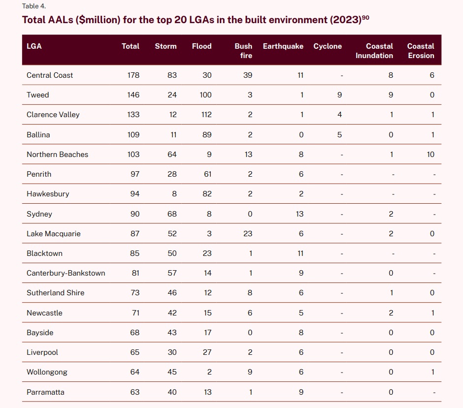
The Central Coast tops the state as the local government area currently at most risk of multiple natural disaster hazards including storms, floods, bushfire, coastal erosion and inundation.
But by 2060 the Coast will slip to second place, with the Northern Beaches moving to the top.
The NSW Government has released the two lists as part of the nation’s first State Disaster Mitigation Plan (SDMP), developed by the NSW Reconstruction Authority.
The plan reveals the cost of building and infrastructure damage from natural disasters could hit $9.1B per year by 2060 if mitigation steps are not taken, as more frequent and severe events take an increased toll on homes, businesses and government infrastructure.
The 2023 average annual loss (cost of damage) from all hazards assessed in the built environment which includes residential, commercial and infrastructure assets was estimated at $3.1B per year.
The report says the hazards that drive the largest potential damage to the built environment today are storm and flood, representing 77 per cent of this average annual loss.
“Natural hazard risk will continue to increase in the future due to both population growth and the impact of climate change, and the relative contribution varies according to the hazard,” the report says.
The Average Annual Loss (AAL) is the expected or average cost of damage to property and infrastructure arising from all occurrences or probabilities of a given natural hazard in any one year.
It is calculated for each hazard and quantifies the expected or average yearly damage to the built environment, which spans residential and commercial property, industrial facilities and infrastructure.
“While this metric is weighted to the built environment it is a useful way to compare the likely impact across different natural hazards,” the report says.
It identifies the top 20 LGAs affected by the greatest number of hazards and with the highest number and density of homes and infrastructure.
The State Disaster Mitigation Plan outlines how the rising costs of disasters can be addressed by refocusing government policy towards risk-reducing actions, and details how government agencies can work together to help communities prepare for worsening bushfires, heatwaves, floods, storms and coastal erosion.
The NSW Reconstruction Authority will help coordinate delivery of the actions to improve community resilience and mitigate against disasters.
Since 2019, NSW residents have endured over 65 declared disasters, costing taxpayers more than $6B, with more than 20,000 homes damaged in 2022 alone.
Climate change is expected to increase the severity and frequency of natural disasters.
The SDMP includes a toolkit of measures to reduce communities’ exposure and vulnerability to disasters through awareness and preparedness campaigns, evacuation infrastructure and warning systems.
The actions include: building a new local government toolkit to guide councils in preparing for disasters and the impacts of climate change; developing local Disaster Adaptation Plans that will inform future planning processes and rebuilding and reconstruction efforts after a disaster occurs; developing early warning systems so communities are better prepared when disaster strikes; identifying mitigation infrastructure strategies and approaches to funding; working with industry to review building codes to factor in greater building resilience through materials and design; reviewing insurance levy arrangements and working with the insurance sector to factor in affordability in adaption planning; and assessing the feasibility of large scale offshore sand reserves and other sources for beach nourishment including locations where it might be suitable.
The 168-page report notes current challenges related to planning controls.
“The number of future assets and properties exposed to significant natural hazard projects will continue to grow under current planning controls,’’ it says.
“There is ongoing pressure for new housing in both regional and metropolitan areas, including housing required to support relocations for purposes of adaptation.”
The report says community awareness of natural hazard risk and preparedness for impacts is low across the state.
The SDMP will be supported by place-based, local and regional Disaster Adaptation Plans (DAPs).
A draft DAP Guideline and Framework will be available for consultation in mid-2024 and the NSW Reconstruction Authority will deliver the next State Disaster Mitigation Plan in 2026, which will identify projects for the longer term.
Merilyn Vale
Fantastic our state govt doing the job for the insurance companies so they can ram it up a bit further without justification Personally I have found where I live on the CC I have dodged a lot of weather bullets Floods Bushfires and storms