

A six-storey development at Terrigal could go ahead after Central Coast Council Administrator Rik Hart set in train the process to increase the maximum height of buildings allowed on the corner of Terrigal Dr and Charles Kay Dr at the March 26 meeting.
Hart adopted a staff report recommending he begin the rezoning process that would increase the building height from 8.5M to 25M.
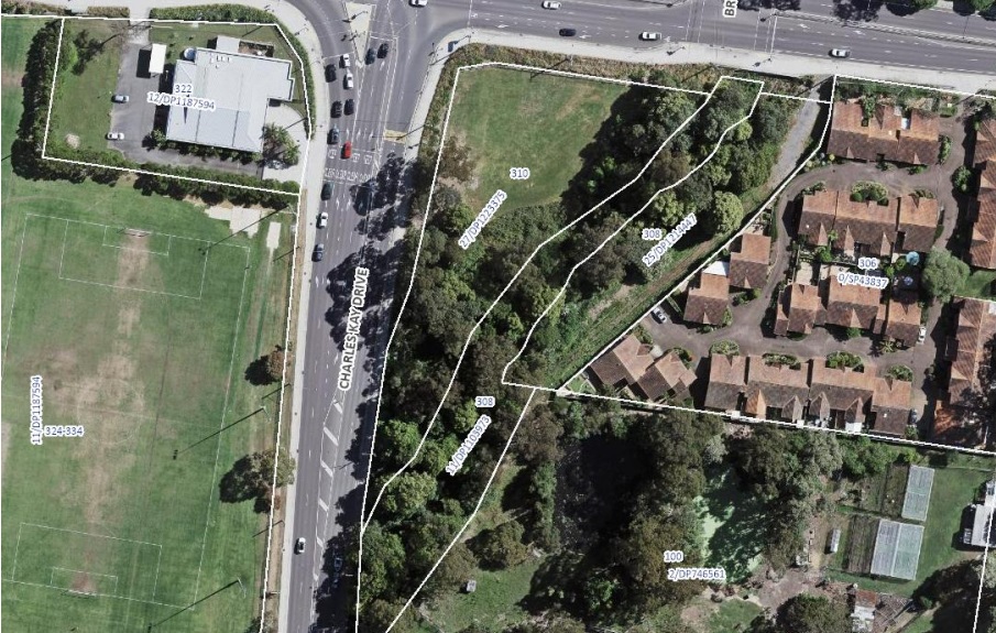
The Local Planning Panel looked at the same proposal but with a height of 32M and considered the proposal did not have strategic or site-specific merit.
The Panel said it failed the site-specific merit test for five reasons.
It said: the site shape and dimensions constrain future development; the traffic access to the site on a busy intersection is constrained and access to the site results in the loss of significant and sensitive vegetation; the density proposed would conflict with the ecological sensitivity of the site together with the potential bushfire and flooding risk; the surrounding development is predominantly single-storey and two-storey form and the proposed 32 metre tower would be anomalous; and the site is not considered a gateway site to Terrigal.
Taking on board those comments, the proposal has been amended to a 25m six-storey building with retail limited to 150m2 on the ground floor.
The report to Hart said the proposal on the vacant land was a “gateway development” that would “uplift residential development potential” in Terrigal.
“The Planning Proposal will better utilise the existing site to allow passive enjoyment of the vegetated area and waterway,” the report said.
Issues with the site include flood risk; traffic management and protection of a riparian zone.
“The site is already zoned for residential use, however the developable area is constrained due to the location of a riparian zone along the 3rd order stream to the south-east of the site,” the report said.
“Due to site characteristics, the developable area is limited and therefore has been strategically positioned to ensure minimal environmental impacts in relation to traffic and transport, flooding and biodiversity.”
Some 3,000m2 of native vegetation would need to be cleared for the development on the site, and according to the Arboricultural Impact Assessment Report, the site has about 200 trees, with 15 requiring removal to facilitate the development.
“This includes cleared land containing exotic vegetation and a small area of low-quality Narrabeen Coastal Blackbutt Forest (approximately 753m2 ),” the report said.
“A hollow-bearing tree identified on the site is also proposed to be cleared.
“Mitigation measures have been identified in the Environmental Assessment to reduce indirect impacts to biodiversity values of the site.
“Assessments of significance were conducted for the threatened flora and fauna species detected on the site, which concluded that the proposal would not result in a significant impact.”
The site is flood affected, with peak 1 per cent Annual Excedance Probability (AEP) flood depths varying across the site.
Towards the creek and within the site, peak 1 per cent AEP flood depths reach 1.5 metres.
However, in the vicinity of the site where the development is proposed, 1 per cent AEP flood depths range from 400mm to 900mm.
In the Probable Maximum Flood (PMF) event, flood depths range from 1,600mm to 2,500mm where the development is proposed.
The impacts resulting from the proposed development are generally isolated to the subject site or the adjoining RE1 zoned watercourse,” the report said.
“There is a minor 12mm increase in peak flood surface levels adjacent to Terrigal Drive, however this does not affect the trafficability of Terrigal Drive and only exceeds the Central Coast Development Control Plan 2022 threshold for a few minutes.
“This was considered acceptable by Council’s Development Flooding Engineer.”
Further studies assessing the impact of climate change-induced rainfall intensity are being undertaken.
On the traffic issue, the report said that key intersections at Terrigal Dr and Charles Kay Dr and Charles Kay Dr and Scenic Hwy currently operate well, with low average delays.
While it said the intersection of Charles Kay Dr and Scenic Hwy operates near capacity and will need an upgrade “at some point in the future” the report said modelling indicates that the proposal would have no significant impact on the future operation of these intersections.
The rezoning will now go to the State Minister for Planning for a gateway determination which is basically a list of requirements for the rezoning submission and then that submission will go out for community input before being assessed again by Council.
Merilyn Vale
well I hope they sort out the water course that apparently runs through that block. disgusting height!!
Bye bye bellbirds, your song will be sorely missed.
Traffic flow…will be a nightmare
If this gets approved it will create a terrible precedent !
Multi storey buildings could be built anywhere.
There is no infrastructure in place to support this type of development now or in the future.
What’s the point of having Zoning regulations if a developer can buy a parcel of land and put whatever they want on it to maximise profits.
Rik Hart doesn’t care he won’t be around much longer.
Inappropriate..eyesore I think.
To propose a multi story high rise development on one of the busiest intersections on the Central Coast is ridiculous.
This is a major intersection on Terrigal Drive being gateway to the Terrigal Beach which is serviced by a single lane road built for last century’s traffic conditions.
This is another reason why Central Coast Council was recently voted NSW’s worst Council.
How much longer does residents have to tolerate this incompetent Council ??
have they taken into account traffic flows at school starting and finishing times. Look at the nightmare created on Davistown Road after a relatively minor development at the Christian school.
It is interesting to note that the Developer has not been named? Isnt that a crucial part of the story? It could explain a lot.