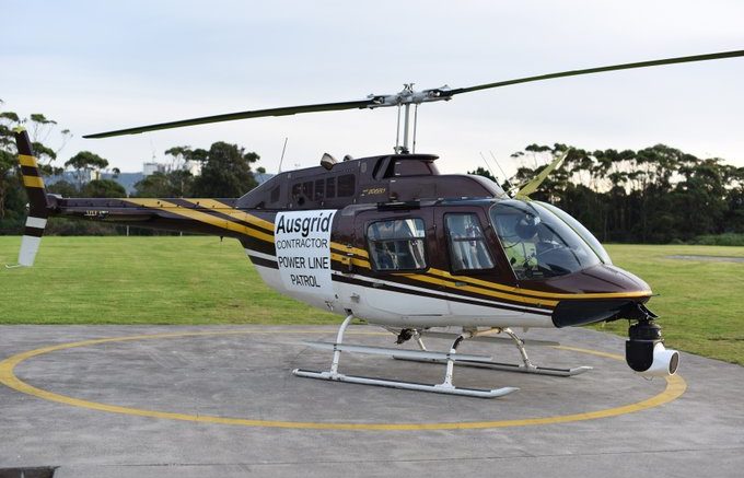
The Ausgrid bushfire prevention program is underway. From today you may see helicopters flying low inspecting the electricity network on the Central Coast.
As part of Ausgrid’s Bushfire Risk Management Strategy we are working with the NSW Rural Fire Service, local councils and community groups to inspect powerlines, poles and other equipment in bushfire-prone areas.
Ausgrid engages specialist contractors to conduct bushfire safety helicopter patrols in parts of The Hunter, Newcastle, Central Coast and Sydney looking for hazards.
The helicopter crews use radar imaging equipment and high resolution photography to identify potential bushfire hazards. The radar sends and records 300,000 pulses every second to create a three-dimensional representation of the network and is capable of identifying branch heights with an accuracy of within two centimetres.
This week the Tuggerah area and surrounds are the focus, including the following suburbs;
ALISON, BATEAU BAY, BERKELEY VALE, CENTRAL MANGROVE, CHITTAWAY BAY, CHITTAWAY POINT, FORRESTERS BEACH, FOUNTAINDALE, GLENNING VALLEY, HOLGATE, JILLIBY, KANGY ANGY, KILLARNEY VALE, LISAROW, LONG JETTY, MARDI, MATCHAM, NIAGARA PARK, OURIMBAH, PALM GROVE, PALMDALE, ROCKY POINT, SHELLY BEACH, SOMERSBY, TACOMA, TACOMA SOUTH, TUGGERAH, TUGGERAWONG, TUMBI UMBI, WADALBA, WAMBERAL, WATANOBBI, WYONG, WYONG CREEK.
Crews will be in the air from about 7.30am to 5.30pm (weather permitting). The helicopters fly between 25 and 40 kilometres per hour and have been modified to allow for the quietest possible operation.
The helicopters need to fly low at times, and this may startle livestock in rural areas, so property owners may want to consider securing livestock during the patrols.
Every endeavour will be made to stick to the flight schedule, however due to factors out of our control, such as adverse weather conditions, it may change slightly. Check back here for updates
Source: Ausgrid social media statement & website May 10, 2020.


