

Woongarrah, HamlynTerrace, Wadalba, Warnervale, and Glenning Valley are the epicentre of residential development on the Central Coast,endorsed by the NSW Government’s Central Coast Regional Plan 2036.
This special report looks at how hundreds of acres of greenfield land and bushland are being transformed into new residential communities.
Index of developments here:
[2] 533 and 539 Pacific Hwy and 24 Van Stappen Rd
[3] 79 Berkeley Rd Berkeley Vale
[4] 700-702 Pacific Hwy Hamlyn Terrace
[5] 200-210 Hakone Rd Woongarrah
[6] 40 to 8 Hiawatha Rd Woongarrah
[7] 31 to 47 Railway Rd Warnervale
[8] 87 Berkeley Rd Berkeley Vale
We have looked at nine recent applications for residential subdivisions that will see over 700 new dwellings built in the north of the new Central Coast local government area in the next two to five years.
The current value of those subdivisions is around $110m, but assuming a new home price of $600,000, developers stand to receive $4.2b as a gross value of the new housing stock from just those nine subdivisions.
For buyers, affordability is a major drawcard for these new housing estates. Scenic quality, proximity to beaches, bush and schools are other attractions.
Infrastructure does need to catch up, or at least keep pace, but it has been promised by the current NSW Government.
The latest plan for growth on the Central Coast, the NSW Government’s Central Coast Regional Plan 2036, still includes a Warnervale Town Centre, but within a broader Warnervale-Wadalba Land Release Area.
Warnervale, 95km north of the Sydney CBD, west of Tuggerah Lakes, and 5km north of Wyong, has been in the spotlight since the 1990s as the site for a new retail, commercial and community growth centre, to be developed over 25 years.
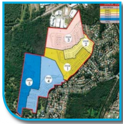
The Warnervale Town Centre was approximately 119 hectares of developable land, bounded by Hakone Rd to the North, Hiawatha Rd to the east, Sparks Rd to the south, and west of the Great Northern Railway line.The site was rezoned to create approximately 15 hectares for retail and commercial uses, and 64 hectares for residential uses, with the remainder, rezoned open space, conservation and special activities, including an eight-hectare nature reserve, created to protect the Commonwealth listed endangered Heath Wrinklewort.
Employment opportunities were to come in the nearby Wyong Employment Zone (WEZ), which would create around 6,000 local jobs and generate a minimum of $1.5bof investment.
Plenty of green, open space was also to be conserved for the new community’s enjoyment. The new houses continue to come online, and have been for the past decade, around Warnervale and
Woongarrah, but also in areas like Glenning Valley, Hamlyn Terrace and Wadalba.
Promised road and rail upgrades, and provision of retail and job-creating commercial developments need to catch up.
In September 2014, Regional Development Australia Central Coast (RDACC) said the NSW Government needed to complete the necessary planning processes and adopt a program to fund and construct the North Warnervale Railway Station, to provide improved access to rail services for residents.
A concept design was completed for the proposed railway station, and initial costs were estimated at $43m.
There are no new railway stations in the Regional Plan 2036, but there is a commitment to “planning for” a public transport interchange at Warnervale.
As for retail, Woolworths was expected to build a supermarket, Big W and 30 to 40 other shops in the Warnervale Town Centre, but has switched to building a new supermarket at Wadalba, and not much else in the north.
Looking forward to 2036, the NSW Government has made some firm promises, in its latest strategic plan, to go ahead with a fresh vision for Warnervale and other new suburbs.
“Warnervale Town Centre will emerge as a new mixed-use strategic centre to service new communities, supported by a new transport interchange,” the plan said.
“Development will support the establishment of a health precinct at Wyong Hospital and expanded retirement housing in the north of the region.
“The Sparks Rd and Pacific Highway corridors will continue to be important for new development areas. “A coordinated review will prioritise delivery, infrastructure and biodiversity offset actions for the Wyong Employment Zone and Warnervale Town Centre.
“This will include consideration of the recent development proposals in the area.”
Actions set out in the new regional plan include leveraging the planned Pacific Hwy upgrade and new link road to improve transport connectivity along the Tuggerah to Warnervale corridor.
The NSW Government has also undertaken to “promote industry-focused investment in the WEZ by resolving infrastructure contributions and biodiversity offsets, including finalising biodiversity certification in the zone”.
The NSW Labor Opposition, namely the Shadow Minister for the Central Coast, Mr David Harris, has made it clear that the current Government’s regional plan for the Coast is reasonable and not likely to be reinvented.
That means there is hope that infrastructure, including road upgrades and employment generating investment, will be on its way to support the thousands of new homes already under construction north of Wyong.
Here’s a snapshot of some of the major residential subdivisions currently in the pipeline in the north of the Central Coast local government area.
There are many others, with more undeveloped land coming onto the market all the time that is ripe for subdivision.
27 – 61 Nikko Road Warnavale
[1] 27 to 61 Nikko Rd, Warnervale 70 residential subdivision DA1029/2017 Value: $24.8m Owned by Kingston Property Fund No 2 Pty Ltd MAP REFERENCE
This DA will be determined by the JRPP because it has a value greater than $20m.
The proposal is for a 70-lot residential subdivision with small lot housing and associated ancillary works. The JRPP undertook a site inspection on March 22, 2017, and discussed outstanding referrals from the Office of Environment and Heritage, RMS and Sydney Trains.
They also indicated that a riparian area may need to be retained and may need to be larger than proposed by the applicant. Solar access to private open space was noted as an issue as was the use of front setback areas and the primary private open space.
The panel considered future access to adjoining residential land to the east, and whether that was reliant on a proposed road that didn’t form part of the current DA.
Bushfire safety, opportunities to retain significant trees, an apparent lack of diversity in housing types, fencing, and details of any sustainability initiatives and measures to reduce the urban heat effect, were also discussed.
A time for a panel meeting is yet to be confirmed. The proposal consists of 30 four-bedroom townhouses, five freestanding four bedroom townhouses, eight three-bedroom semi-detached townhouses, nine freestanding three bedroom townhouses and 18 four-bedroom freestanding villa units.
The land is zoned R2 Low density residential, except for the environmental corridor crossing the northern portion of the land.
The total area of the site is 35,947 square metres. “With the rapidly growing demand for housing on the Central Coast, and the allocation of this area as part of the Warnervale South Land Release, this site is perfectly suited for a housing development of this type,” according to the applicant.
“The site is well supported with convenient access to the local bus service, train station linking to Sydney and Newcastle, sporting facilities, schools and other community activities.”
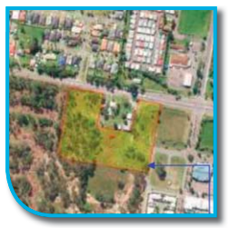
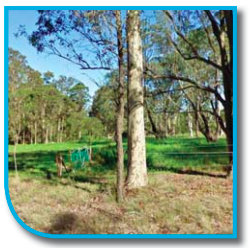
533 and 539 Pacific Hwy
[2] 533 and 539 Pacific Hwy and 24 Van Stappen Rd, Wadalba Residential subdivision including small lot housing, 66 lots in two stages and associated works DA1545/2017 Owned by: NL Gentile Pty Ltd Value: $20.7m
This application has been registered with the Joint Regional Planning Panel as it has a value greater than $20m.
The land is zoned R2 Low Density Residential, it is currently vacant and is bushfire affected.
The site is located centrally within the Wadalba Township. The application seeks consent for Stages 5 and 6 of an overall masterplan development of the land.
Stage 5 would create 31 small lots for single dwelling houses and stage 6 would see the creation of a further 35 small lots for single houses. Most lots are in the low 200 square metre range with a few making it up to low 300s.
They are smaller than the required 450 square metre minimum for R2 zoned land. According to the applicant: “We note the provisions of Clause 4.1B (3) that permits the subdivision of land into 5 or more lots of a size that is less than the minimum size shown on the Lot Size Map in relation to that land, and incorporates the erection of a dwelling house on each lot resulting from the subdivision.
“The proposal seeks consent for the creation of 66 lots, with the subsequent erection of a single dwelling house on each small parcel.
“Lot sizes proposed range in area from 200.03m2 (Lot 181) to 357.74m2 (Lot 128).”
The north eastern corner of the land is affected by flooding, but generally correlates with the part of the site to be set aside for drainage purposes.
“Individual dwelling designs have been submitted for each allotment as part of this application.
“The design of individual dwellings is varied and provides architectural interest in the context of the proposed subdivision,” the applicant said in relation to the building design for small lot housing.
“We note zero boundary setbacks proposed for some of the proposed dwellings. “In all instances, the proposal retains a 1m wide maintenance zone including maintenance easement on the adjoining title.”
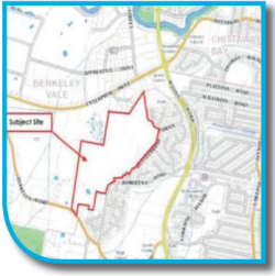
79 Berkeley Rd
Berkeley Vale 127 Lot Subdivision DA1438/2015 Owned by: GV Nominees Value: $14m
This subdivision was approved following a decision by the Land and Environment Court on November 9, 2017.
Nearly 300 submissions were received by Central Coast Council objecting to the project. The subject site was zoned R2 low density residential and E2 Environmental Conservation.
The E2 portion of the site was centrally located and linked to additional E2 land to the west of the site and along a corridor at the northern end.
The original proposal sought to create 264 residential lots of varying sizes with associated roads, and a 5,000 square metre park.
The applicant proposed to install all required services including water, sewer, power, telecommunications and stormwater controls. Lots were to range in size from 450 square metres to 2,022 square metres, with an average size of 558 square metres.
The subject land is an irregular shape totalling 38.2 hectares, with frontage to Berkeley, Bundeena and Bottlebrush Rds. The site contains significant areas of vegetation.
Part of the site was identified as a wetland management area. According to the applicant: “The site not only provides… dwelling lots, but seeks to conserve and improve a large portion of environmentally significant land for public benefit through the transfer of the E2 portion of the site to Council, with a vegetation management plan for the ongoing maintenance of the land, and a property vegetation plan over part of the E2 land.”
According to the applicant: “The subject site is identified as being located within the Glenning Valley Urban release area.
“The proposed development has been strategically designed to be sympathetic to the significant environmental, topographic and visualattributes of the subject site.
“Development of the proposed subdivision will be undertaken in a manner that will enable the integration of the site with adjoining land and land uses, and provide a high standard of residential development for present and future residents within the Glenning Valley area, whilst also protecting the ecological values of the site,” the applicant said.
The subject site is classified as bushfire prone land and required the approval of the Rural Fire Service who issued a Bushfire Safety Authority.
700-702 Pacific Hwy
Hamlyn Terrace DA4/2016 Owned by: The Lateral Thinking Group Pty Ltd Value: $13.96m
This application for a 91 small lot housing development, subdivision, and demolition of existing structures, has been amended four times since it was first submitted in January, 2016.
The latest version was submitted in April. The land is currently vacant apart from an existing dwelling. The 3.9 hectare site is currently zoned R2 Low Density Residential.
The subject site is located on the western side of the Pacific Hwy, between Sparks Rd and Craigie Ave, Hamlyn Terrace.
It has a frontage to the Pacific Hwy on its eastern boundary, Georgia Dve on its southern boundary and Violet Rd on the western boundary. It slopes from the south-eastern corner to the north-western corner, with a cross fall of approximately 9m across the site.
The subject site is located within an urban release area.
“Unless otherwise stated, the proposed lots achieve the minimum standard lot size of 450 square metres for the R2 zone,” according to an assessment report prepared by Central Coast Council staff.
“The proposal seeks… approval for the subdivision and the existing dwelling house under a single application for the 91 small lot subdivision. The subdivision is located in mine subsidence area.
Modifications to the original DA appear to be minor and relate to the timing of contribution payments by the developer to council.
A modification lodged on March 14, 2017, was to remove temporary onsite stormwater detention systems and create a four metre wide easement over one of the lots.
“Suitable arrangements have been made with owners of the neighbouring site for a drainage easement to be provided over 704 Pacific Hwy, so that the subject site can drain to the existing stormwater drainage system on Cedarwood Rd,” the applicant said.
The latest amendment was lodged on April 19, and is currently under consideration by Central Coast Council staff.
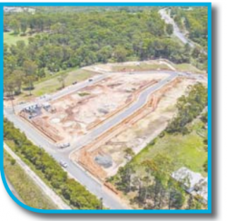
200-210 Hakone Rd
Woongarrah 88 Lot Residential Subdivision, 3 stages, ancillary works and residual lots DA363/2018 Value: $10.5m Owned by: Stannic Securities Pty Ltd
This proposal is under assessment and was being prepared for notification on April 21.
The land is zoned R1 General Residential, RE1 Public Recreation, E3 Environmental Management and E2 Environmental Conservation.
The proposed subdivision is permissible, with consent, and there is no minimum lot size. The project is within the Warnervale Town Centre urban release area.
The subject site is located on the southern side of Hakone Rd, to the north of Mary Mackillop College, within the Warnervale Town Centre.
The proposed development involves the creation of 88 residential lots in three stages, a super lot for future medium density development, a residue lot, and associated infrastructure.
The residential lots range in size from 341.4 square metres to 621.5 square metres, where larger lots are generally proposed for corners or irregular shaped lots. Consent is also sought for bulk earthworks, retaining, connection to services, landscaping, two regional bio filtration stormwater basins, a temporary sewer pump station (SPS) and vegetation removal.
The majority of the site is zoned R1, and the E3 and E2 areas are generally corresponding to a first order water course and associated buffers which traverse the site, and the RE1 representing a future local park.
The site is covered in two types of vegetation: Smooth-barked Apple Red, Bloodwood open forests; and, Spotted Gum, Grey, Ironbark open forest.
Neither of these two communities represents an Endangered Ecological Community (EEC), according to the applicant.
Regardless, clearing of this vegetation was captured under the Biodiversity Certification of the site.
Site access to the north is available from Hakone Rd, which will require upgrading as part of the proposed development.
Access will also be made available to the south via the extension of Mataram Rd. The site contains land which will be acquired by Council to be used as a local playground referred to as Ridge Park East.
This land will be dedicated to Council as part of this DA, with the associated land value being applied as a credit to the payable contributions.
The site makes up a large portion of the Warnervale Town Centre and represents one of the first to occur within the area.
The proposed development complies with the relevant provisions of Wyong LEP 2013, as well as the aims and objectives of the various chapters within the Wyong DCP 2013, according to the
applicant.
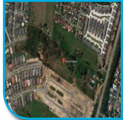
Approval was given to a 97-lot subdivision and demolition of existing structures in February for this site, which is located within the Louisiana Rd, Hamlyn Terrace Urban Release Area.
An amended application was lodged on April 26. The land is a vacant, disused, golf driving range, and the application was for 96 residential lots and one environmental lot.
Development consent will lapse on February 4, 2023. The site area is 99,950 square metres and the land is zoned a combination of E2 Environmental Conservation, R1 General Residential,
and E3 Environmental Management.
The land is on the northern side of the Pacific Hwy and is approximately 5km northeast of Wyong. The R1 General Residential part of the land is an area of 5.095 hectares.
The site slopes from the southern to northern boundary, and is burdened by a sewer main, which dissects the property in an east-west direction. It is identified as bushfire prone land, partially flood-affected,
and within the Swansea North Entrance No 1 Mine Subsidence District, and is partially affected by acid sulphate soils within the north western corner, which will be contained within the proposed residue lot.
The residential allotments ranged from 192 square metres to 588 square metres. The WLEP 2013 Lot Size Map does not specify a minimum lot size for the area of the site that is zoned R1 General Residential.
The portion of E2 and E3 land in the northern area of the site is proposed to be created as a separate lot (lot 97), which is to be excised from the rest of the subdivision.
The development will include construction of roads, re-grading the site to ensure adequate transition of road levels to allotments, flooding compliance and to accommodate stormwater flows and
sewerage servicing.
The developer is responsible for provision of underground water, sewer and electrical services, and the removal of trees and vegetation within the residential subdivision footprint.
A stormwater sediment basin and wetlands will be constructed within the portion of the site zoned E3.
Approved stamped plans from Subsidence Advisory NSW were submitted with the DA, demonstrating that the development was supported within the mines subsidence district.
The proposed subdivision gains access to Minnesota Rd via the proposed road at the northern end of the residential subdivision.
The proposed development will be filled where necessary to ensure that all residential allotments are above the one percent ARI floor event, ensuring future potential events will not result in unsustainable social and economic costs to the community.
The proposed development occurs within the highly modified section of the site that is already largely cleared of native vegetation.
The vegetation proposed to be removed is not deemed significant in regards to biodiversity values.
Consideration has been given to the amenity of residential lots fronting or within close proximity to the Pacific Hwy.
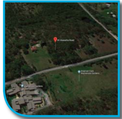
40 to 8 Hiawatha Rd
Woongarrah 84-lot subdivision DA490/2017 Owned by: The Lateral Thinking Group Value: $4.4m
This subdivision proposal was refused by Central Coast Council on April 11.
The site area is 56,660 square metres.
The zoning is R1 General Residential and RE1 Public Recreation. The recommendation was that the DA had not satisfied Clause 6.2 of the WLEP 2013, by demonstrating that the site and the development will be adequately serviced by essential infrastructure.
“The proposal is not supported by sufficient information to assess the potential impacts associated with traffic generation and vehicular access,” Council’s assessment report said.
“The proposal is also not supported by sufficient information to assess whether the site has adequate stormwater drainage in accordance with Council’s specifications and requirements; is not considered to be supported by adequate information to enable a full assessment of the potential impacts of the proposal and demonstrate that the site is s suitable for the proposed development; is not supported by a Geotechnical assessment required to investigate the suitability of the site; and, is not supported by sufficient information to assess whether the proposed residential allotments may support subsequent development for residential purposes.”
There is an existing dwelling located in the cleared mid portion of the site which is otherwise vacant land, comprising areas of thick vegetation interspersed with cleared areas, including a farm dam.
Though not designated by the WLEP 2013, it is noted that the site is mapped as being bushfire prone land.
The proposed development is comprised of the subdivision of the site to create 84 residential allotments, ranging in size from approximately 285 square metres to 829 square metres, and associated roads and services.
The site is currently not connected into Council’s water supply network, and a new 150mm water main would need to be constructed by the applicant up to the site boundary.
“The development application does not contain details of how this is to be provided, including any relevant land and infrastructure owner’s consent.
“The development application contains no details of a proposed interim sewer service or relevant land owner’s consent for the construction of an interim system and therefore adequate arrangements for sewer services have not been made.
31 to 47 Railway Rd
This land is currently on the market.
Consent for the subdivision was granted on May 10, 2016, and will lapse on May 10, 2021. In September, 2016, amendments were approved to the internal road alignment, lot layout and dedication of land to Council.
The approval was for a 38-lot residential subdivision on 3.82 acres, zoned R2 low density residential and E3 environmental management.
The land is bound by Sparks Rd in the north and Railway Rd in the south. Lot 1 contains a dwelling located towards the Railway Rd frontage.
The land to the rear of the site contains thick vegetation.
A drainage corridor zoned E3 is located in the north western corner of Lot 1. Drainage along this corridor is provided to the development to the north of Sparks Rd, with stormwater flowing via the drainage corridor to the wider downstream catchment to the south.
The E3 zoned land will be dedicated to Council, as required by the Warnervale South Contributions Plan.
The site is not connected to water or sewer infrastructure. The area is part of the Warnervale South urban release area.
The Main Northern Railway corridor is located opposite Railway Rd to the South. The land along Sparks Rd has been identified for acquisition for road widening and will be dedicated to RMS.
The residential subdivision will be undertaken on the eastern side of the site.
All residential lots will be located outside the E3 zoned drainage corridor.
A parcel of residentially zoned land will also be located within the north western corner of the site.
It is proposed that the drainage infrastructure be located within the E3 zoned land and proposed Lot 7, which will therefore also be dedicated to Council.
The lots will be located along two access roads, that will be linked with an access road that will provide through access to the future development within the adjoining land to the east.
The residential lot sizes will vary between 450 square metres and 922 square metres. The residue residential land (Lot 39) will comprise 3,200 square metres.
The site will be serviced from the existing water and sewer connections along Sparks and Railway Rds.
While it is generally accepted that largescale tree removal will be required, the retention of trees, where possible in greenspaces and suitable positions on larger allotments, will assist in minimising the impact of development upon the local environment, and assist in maintaining the visual amenity of the location.
The land contained within the E3 zone has minimum lot size of 40ha.
As the E3 zoned land is not being subdivided as part of the proposal, the minimum lot size provision does not apply.
Development consent must not be granted for the subdivision within Warnervale South unless the DirectorGeneral has certified in writing to the consent authority that satisfactory arrangements have been made to contribute to the provision of designated State public infrastructure.
The applicant entered into negotiations with the Department of Planning & Environment regarding the infrastructure requirement of the site.
The Department of Planning & Environment issued a Secretariat’s Certificate stating that satisfactory arrangements had been made.
The north western portion of the site is identified as flood prone by Council mapping.
The internal referral from the Council engineers confirmed that the residential lots can be safely developed.
All the habitable rooms of future dwelling must be located 500mm above the one percent AEP level.
The applicant has shown that electricity services for the development are also available.
The number of vehicles generated by the proposal does not exceed the relevant trigger, and referral to the RMS is not required.
A shared pathway will be required along the main access road connecting Railway Rd to the land to the east, shown as Honey Myrtle Rd.
87 Berkeley Rd
Berkeley Vale 83-lot subdivision DA326/2018 Owned by: Berkeley
Vale Holdings Pty Ltd Value: Unknown
This application for a staged residential subdivision on land zoned R2 Low Density Residential and E2 Environmental Conservation has been referred to external agencies.
The E2 portion of the site is located within the north-eastern corner, and links to additional E2 land to the north and east of the site.
The proposal seeks to create 79 residential lots of varying size, one residue lot, two stormwater management lots, and one environmental conservation lot to contain the environmental portion of the site.
Roads, water, sewer, power, telecommunications and stormwater controls will also be provided under the proposal, which has been designed to integrate with the approved residential subdivision adjoining to the east (DA1438/2015).
The proposed residential lots range in size from 450 square metres to 868 square metres.
The subdivision is to be carried out in two stages and will not proceed until such time as the residential subdivision approved under DA1438/2015 is under construction.
A portion of the site is mapped as a “wetland management area”. A Water Cycle Management Plan for the proposal has been designed to minimise potential impacts to nearby wetlands, with an emphasis on not only the quality and quantity of watering entering the wetlands from the site, but also on maintaining the wetting/drying cycle within the wetlands.
The rezoning of the site stemmed from the Central Coast Regional Strategy and identified under supply of housing in Wyong Shire.
The proposal involves the staged Torrens Title subdivision of Lot 22 DP 740435 as follows: Stage 1, 45 residential lots (101-145), one residue lot (146), stormwater management facility – pond (47) and internal roads; Stage 2, 34 residential lots (201 – 234), environmental lot (236), stormwater management facility –constructed wetland (235), internal roads, removal of 7.57ha of native and non-remnant vegetation within the R2 zone portion of the site, benching and retaining walls, provision of underground water, sewer and electrical services as required, and
creation of any necessary easements.
The E2 zoned land, an area of approximately 3,451 square metres, is proposed to be dedicated to Council.
A Koala record exists as a single scat collected from within Blackbutt Open Forest (Travers 2010), but despite subsequent targeted surveys and Koala habitat assessments, no further evidence of utilisation by Koalas was encountered.
As the proposed subdivision will create less than 200 lots, and is not located within 90m of a classified road, the development is not classified as traffic generating development, and a referral to RMS is not required.
The subject site is identified as being located within the Glenning Valley Urban Release Area.
“Development of the proposed subdivision will be undertaken in a manner that will enable the integration of the site with adjoining land and land uses, and provide a high standard of residential development for present and future residents within the Glenning Valley area, whilst also protecting the ecological values of the E2 zoned portion of the site,” according to the applicant.
The subject site is identified as bushfire prone land. A Biobanking Assessment Report has determined a total of 287 ecosystem credits (Smooth-barked Apple – Turpentine – Blackbutt Open Forest on the ranges of the Central Coast or equivalent) as being required to offset the proposed development.
The Say No to Glenning Valley Development Group has been fighting this subdivision since 2016.
Group organiser, Ms Kylie Boyle, recently wrote to Mayor Jane Smith arguing that the subdivision would “result in further removal of listed threatened species as well as removal of foraging resources for threatened, vulnerable and critically endangered listed species.
“The lot sizes are small in comparison to the existing residential area… 69 percent of these are less than 500 square metres.
“This is a condensed housing development that aligns to Western Sydney developments and should not be something that we accept on the Central Coast.
“Any kind of development will impact upon the SEPP14 Wetlands and the E2 zoned area, and you can’t educate all residents to be mindful of their daily impact.
“We ask that the council takes responsibility to preserve our Wildlife Corridors, Wetlands and the Endangered Ecological Communities and reject this development.”
Source: Wyong DA Tracker, Apr 27, 30 and May 1 Central Coast Council