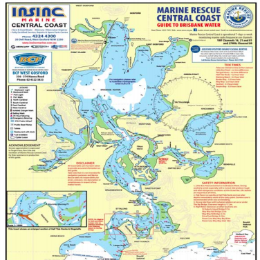

Marine Rescue Central Coast has released an updated colour map of Brisbane Water.
The updated Guide to Brisbane Water is laminated for use on boats. The publication shows all current navigation marks, lights and channels, in particular, the notorious ocean bar at Little Box Head. Included on the guide are all public launching ramps, public jetties, available toilets and public mooring locations. The map enables recreational boaties and fishermen to safely navigate the many tricky channels on and around Brisbane Water.
It will assist visitors to locate local restaurants with boat docks and it includes all marinas and fuel locations as well as other safety information for those using Brisbane Water. The new map is available direct from Marine Rescue Bases at Pt Clare at the end of Kurrawa Ave seven days a week and at Terrigal Haven on weekends. It is also available from many popular boating, bait and fishing shops. Unit commander Mr Roger Palmer said: “This map is great value for just five dollars.” All proceeds will be used to support the volunteer Marine Rescue Central Coast service.
SOURCE: Media release, 6 Feb 2018 Roger Palmer, Marine Rescue Central Coast