

Residents of the Lower Hawkesbury feel somewhat more prepared for future flood events following a meeting on September 24 with representatives from Central Coast Council and emergency services, but questions still remain over possible spillage from Mangrove Creek Dam.
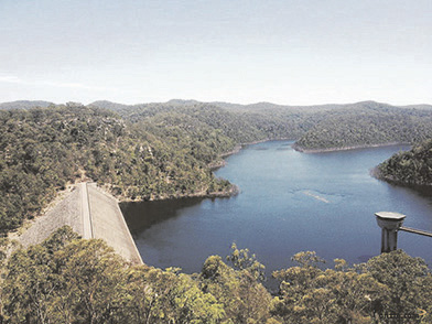
River Cares President, Robyn Downham, said the first part of the morning was dedicated to the building, management and safety of the dam, which reached 100 per cent capacity for the first time ever during heavy storms in July this year.
“We were told that the dam, built between 1978 and 1982, was designed with a spillway in case it overflowed and that it was not expected to fail,” Downham said.
“It is designed and built to withstand a one-in-a-million-year flood and there are daily visual inspections checking for cracking, deformation, damp spots etc.
“We were told there is also online monitoring and if there was a seepage there would be an alert.”
Council’s Section Manager, Bushfire and Flood Risk Management, Peter Sheath, told the meeting flooding from July 2-7 this year was the worst since 1867 and saw the dam reach capacity and start to spill.
“Mr Sheath told us there was no expectation that the dam would fail but there was a very small chance it could happen.”
robyn downham
“Dam safety engineer Joe Weston told us that legislation empowers a body called Dam Safety NSW, which ensures that various processes are in place for the safety of dams, including identification and assessment of risks and ensuring continuous improvement.
“We also discussed the Dam Safety Emergency Plan, which helps enable a collaborative approach, identifying and evaluating potential situations, providing a system of timely notifications.
“Modelling helps to see who will be affected and how much, and the time aspect to any flooding, with the objective of giving as much notice (as possible) by the Council and the SES to the residents along Mangrove Creek.
“It outlines how to deal with certain situations as best as can be predicted and procedures for responding if something happens and for notifying stakeholders.”
Downham said while residents found the information impressive, there was still concern that there is no plan in place for pre-emptive spillage when the dam is at full capacity.
“The Council talked about damage/danger mitigation etc but it is only since the dam spilled in July that they have assessed who actually lives or owns property downstream and whose lives/animals/property might be impacted by the spill,” she said.
Residents are also concerned that there are no official reliable procedures as to how they can be notified in case of emergency spillage, with a telephone tree ineffective when the landlines go down, as they do during many flood events in the area.
“Until the CB radio network is established how are the people along Mangrove Creek be notified, especially those residents without mobile coverage?” she said.
She suggested something like a klaxon warning system was needed to provide people downstream with adequate notice.
Flooding in the area was often impacted by overflows from the Hawkesbury River and Warragamba Dam as well as Mangrove Creek Dam, she said.
She said Council and the SES need to understand that the tides at Mangrove Creek and the issues there are completely different to those in Spencer.
“There was no mention about the regular maintenance checks on the holding tanks and pressure valves – for example at Pembertons Hill Rd, where water was pouring out of the holding tank in August,” she said.
The second part of the meeting was driven by Superintendent Darrell Jobson from Brisbane Water Police, who explained that SES is the combat agency for flooding and the RFS is the combat agency for fire, with all services committed to doing their best for the community.
He told residents they should learn from what happened in the recent floods and not be complacent.
“If you know you are going to be isolated, decide to get out – either self-evacuate by staying with friends or family or leave when the SES arrives with a bus to take you to an evacuation centre,” he said.
“If you are going to stay, make sure you have enough provisions to last for at least two weeks.”
“Mandy Bramble from the SES reviewed issues that arose from the March and July floods,” Downham said.
“(She said) when the SES travels by boat to deliver fuel to households, they need to have adequate signage with street numbers clearly displayed and ‘V’ markers if being airlifted by helicopter.
“She stressed the point that if an evacuation order goes out and people choose to stay, they must have enough water, food, fuel and medications for at least two weeks.”
Downham said residents requested additional and adequate flood markers along Wisemans Ferry Rd, with Council’s Unit Manager Community and Culture, Glenn Cannard, replying there is a process involved before installing them and the same applies to rain gauges.
“The SES advised it is introducing a new national warning system which comes into play at the end of September,” Downham said.
Residents were given a rundown of emergency procedures and liaison between various agencies and of the challenges faced by SES over the past few years with fires and flooding.
Jobson urged residents to work with emergency services and Bramble reiterated they should stay up to date by watching TV news, heeding all warnings put out through ABC radio and paying attention to SES notifications on social media such as Facebook.
Downham said residents were grateful to Council for organising the meeting and to the RFS, SES and Department of Community and Justice for sending representatives, along with Kariong-Somersby Rotary Club, which provided sausage sandwiches even during a massive thunderstorm.
Water level remained below alert levels: Council
Although Mangrove Creek Dam filled to 100 per cent and water flowed through the spillway during the July flood event, the water level remained below any alert levels in the Dam Emergency Plan, Central Coast Council says.
A spokesperson said the dam is now sitting at 99 per cent and is being used to supply water to both water plants.
“Council has a Dam Emergency Plan for all of its water supply dams, including Mangrove Creek Dam,” the spokesperson said.
“This plan provides guidance for the management of various emergencies including flooding.
“The Plan outlines the water levels that trigger activation of the Plan and notification to other agencies, such as the NSW SES.
“If any alert level is reached, Council manages notifications and response in line with the Plan.
“The NSW SES assumes a lead agency role in relation to community management, including managing any evacuation warnings and orders.
“These are issued using the same processes that the NSW SES has for general flooding.
“Council’s primary responsibility is to monitor and manage the dam.”
council spokesperson
The spokesperson said the Mangrove Creek Dam Emergency Plan is a confidential document …. but Council has prepared a public summary which will soon be available on its website.
“Although the SES is the lead agency responsible for public communications during a flood emergency, Council is aware of communication challenges in the communities downstream of Mangrove Creek Dam,” the spokesperson said.
“Council has community development programs in the area to improve communications support for the community during extreme weather events.
“This includes leveraging existing information sharing methods in the community, such as phone trees.
“These methods were utilised to provide local representatives with updates during the July flood.
“Council is in the process of scheduling regular engagement activities with residents in those areas linked to ongoing resilience and disaster preparedness and that will provide an ongoing source for information exchange and dialogue.
“Mangrove Creek Dam is a water supply dam, not a flood mitigation structure.
“When Mangrove Creek Dam spills, the volume of water is the equivalent of the natural flows that would ordinarily be entering Mangrove Creek from the upstream catchment – the dam does not increase the volume of this water.
“Flows recorded in the July flood were at a relatively low rate and small in comparison to downstream catchment flows, particularly when compared to the flows from the significantly larger Hawkesbury River catchment.
“For comparison, the July flood maximum flow over the MCD spillway was approximately 2 gigalitres per day, considerably smaller than the Warragamba Dam which was spilling at 515 gigalitres per day at its peak.”
Source:
Media release, Sep29
River Cares
Media statement, Sep 29
Central Coast Council