

Foreshore barriers at both Davistown and Empire Bay, a review of evacuation centres and sea wall construction guidelines are among the recommendations in the Davistown and Empire Bay Floodplain Risk Management Study and Plan, adopted with some minor amendments by Central Coast Council at its October 11 meeting.
Council commissioned Rhelm Pty Ltd to prepare the documents, which outline the nature and extent of existing flooding issues and recommend actions to better manage the existing, future, and continuing flood risk in the Davistown and Empire Bay catchments.
A report to the meeting said the Davistown catchment consists primarily of the suburb of Davistown, situated to the south of Saratoga and surrounded by foreshore areas and surrounding waterbodies to the east, south and west – The Broadwater, Cockle Bay, Cockle Channel and Lintern Channel.
The Empire Bay catchment consists of the suburb of Empire Bay and the south‐western section of Bensville.
Cockle Channel and Cockle Bay are the water bodies situated on the northern side of the catchment.
The study area includes much low-lying land in Davistown and Empire Bay which is both flood prone and subject to tidal inundation.
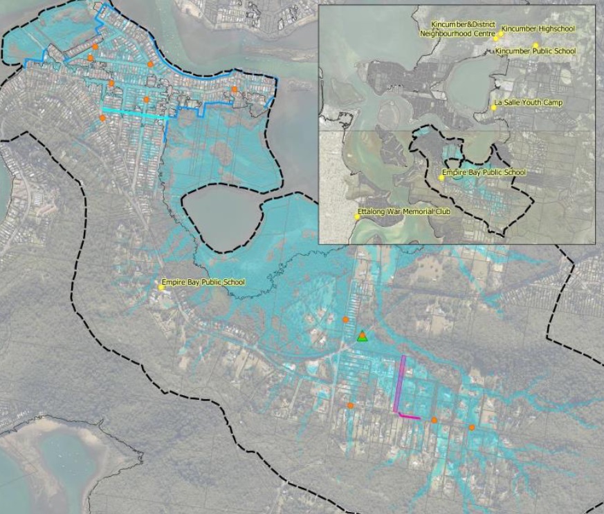
The report found that Brisbane Water overflow as a result of ocean storms often led to flooding of the low-lying areas, with flood levels typically rising and falling over several hours and reaching depths of 0.5m.
Other major contributors to flooding issues were intense rainfall, with the most significant flooding occurring as a result of a two-hour duration storm event, and tidal inundation during high tides.
“The existing flood risks associated with tidal inundation are not significant in Davistown and Empire Bay in comparison to the other mechanisms of flooding,” the report said..
“However, it is expected that in the future, as a result of sea level rise, a large proportion of the study area will be subjected to relatively frequent inundation from high tides.”
report to council
“This will compromise the liveability of some portions of the suburbs through flooding of roads, services, and private properties.
“It should be noted that the effects of climate change will potentially aggravate the impacts of all three types of flooding in Davistown and Empire Bay.
“As a result of sea level rise, it is expected that the magnitude and frequency of Brisbane Water flooding and tidal inundation will increase considerably.
“Additionally, the higher ocean level will compromise drainage conditions and exacerbate the consequences of local catchment flooding.”
The FRMSP outlines a number of recommended measures including flood mitigation works, emergency management plans, flood warning processes, land use planning, and suitable design of infrastructure and buildings.
Now that Council has adopted the plan, it can seek further grant funding assistance for costs associated with the implementation of the recommended actions.
The documents can be viewed on Council’s website.
Source:
Central Coast Council agenda, Oct 11