
Central Coast Labor has sought clarification from the Office of Local Government (OLG) regarding the ward boundaries in the new Central Coast local government area (LGA).
According to the President of the Central Coast Labor Local Government Committee, Mr Jeff Sundstrom, the way the ward boundaries have been drawn up could breach NSW regulations.
According to the Local Government Act 1993: “The division of a council’s area into wards, or a change to the boundaries of a ward, must not result in a variation of more than 10 per cent between the number of electors in each ward in the area.”
“The proposed wards may have significant voter population variations,” Mr Sundstrom said.
“As far as we can see, the difference in sizes of the West Gosford (38,000) and East Gosford wards (30,000) represents a considerable size difference, well above the 10 per cent limit.
Mr Sundstrom said: “An OLG spokesperson suggests in reply to our concerns, that the matter would be best dealt with after the September 9 elections.
“By design or incompetence, this has all the hallmarks of a gerrymander,” he said.
“Representation for residents has already been reduced through this amalgamation.
“Now it appears some 30,000 residents will benefit from a lower voter to councillor ratio than other voters.
“Waiting until after the election will mean that voters will have to wait until the next election before they vote, and are located in wards that are not compliant with the Act,” he said.
Mr Brian Glendenning, Central Coast Council’s Executive Manager of Governance, said the number of electors for each ward had been calculated by a table issued by the NSW Electoral Commission on January 24, 2017, but the ward boundaries were drawn up prior to the proclamation that dissolved the Gosford and Wyong Councils and created the Central Coast Council almost a year earlier, on May 12, 2016.
According to the January 2017 numbers, the number of electors in each ward did not vary by more than 10 per cent: Budgewoi had 50,225 voters; Gosford East had 49,724; Gosford West 49,825; The Entrance 48,639; and Wyong 49,752.
In January 2017, the NSW Electoral Commission also responded to questions from Coast Community News about how the boundaries were drawn up for the wards within the new Central Coast Council.
Coast Community News had conducted its own research, with assistance from Dr Van Davy of Pearl Beach, and found that, based on voter numbers at each polling booth in each of the five wards at the 2016 Federal election, the variation between wards was greater than 10 per cent in some instances.
In a written statement at that time, the NSW Electoral Commission said: “Boundaries for the new wards in the Central Coast Council were reviewed by the NSW Electoral Commission.
“The NSW Electoral Commission used the electoral roll and geo-spatial analysis tools to assess and review the number of electors in each proposed ward, as required under section 210A of the Local Government Act 1993.
“The wards proposed for the Central Coast Council met this requirement at the time of the review.
“Electors are allowed to vote at any polling place for any Federal Division in Australia, and hence polling place attendance figures are not a reliable indication of local council enrolment numbers.”
However, the carefully-worded statement did not clarify that it was, in fact, the NSW Electoral Commission that determined the ward boundaries for the Central Coast Council in the lead up to the May 12, 2016 Council merger.
Coast Community News also asked the then Minister for Local Government, Mr Paul Toole, for further clarification, as it was understood that most decisions made relating to council mergers were made within the NSW Department of Premier and Cabinet.
The following statement came back from Mr Toole’s office: “New council ward boundaries were authorised by the NSW Electoral Commission to ensure they complied with the ten per cent variance rule’ in accordance with the Local Government Act.
“In some instances major roads, residential roads, railways or parks were used as the boundaries for the wards to ensure the ten per cent variance rule was met,” the statement said.
The Minister’s office also clarified that all further questions relating to data used to determine ward boundaries should be directed to the NSW Electoral Commission.
Coast Community News was also told, by the Minister’s office, that the five Central Coast wards ranged in enrolment from 48,400 to 49,500 – a different set of figures to those provided to NSW Labor by Central Coast Council.
A former Gosford councillor, who did not wish to be named for fear of being ejected from the Central Coast Council’s Local Representation Committee, said they also believed the ward boundaries clearly discriminated against residents in the former Gosford City LGA.
“Only two of the five wards are Gosford City wards so the representation of the former Gosford council ratepayers has arguably fallen from 10 councillors to six,” the former councillor said.
None of the NSW Government sources consulted by Coast Community News thus far has produced primary documentation clarifying what data was used to set the ward boundaries prior to the proclamation on May 12, 2017.
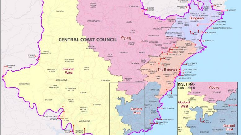
Central Coast Council has a map of the ward boundaries on its website.
Source:
Media release, May 2
Jeff Sundstrom, Central Coast Labor
Media statement, Jan 11
Ashley Gardiner, office of Paul Toole
Media statement, Jan 11
Charles King, NSW Electoral Commission
Jackie Pearson, journalist