

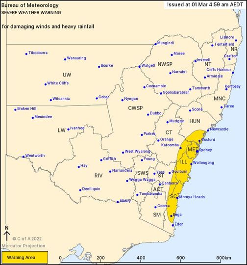
Bureau of Meteorology, Tuesday, March 1: A Severe Weather Warning for heavy to locally intense rainfall has been issued for Greater Sydney, Central Coast, Illawarra and South Coast and parts of adjacent districts.
The weather system is expected to cause riverine flooding for the parts of the Mid North Coast today and extend further south to the Central Coast, Sydney, Illawarra and South Coast catchments from later on Tuesday.
A slow moving coastal trough lies off the northern NSW coast. Later on Tuesday a low pressure system will form within this trough before moving towards central parts of the NSW Coast and deepening into an East Coast Low. Heavy to torrential rain is likely to the south of the low affecting Sydney, Illawarra and the South Coast from later on Tuesday.
MINOR FLOODING POSSIBLE FOR THE PORT MACQUARIE COAST AND CENTRAL COAST
Catchments likely to be affected include:
Hastings River – minor flooding
Central Coast – minor flooding
Upper Nepean River – moderate to major flooding
Hawkesbury and Lower Nepean Rivers – minor to moderate flooding
Colo River – minor to moderate flooding
Flood classes (minor, moderate, major) are only defined for catchments where the Bureau provides a flood warning service.
For the latest flood and weather warnings see www.bom.gov.au/nsw/warnings/
For the latest rainfall and weather forecasts see www.bom.gov.au/australia/meteye/
For the latest rainfall and river level information see www.bom.gov.au/nsw/flood
Information source: Australian Government Bureau of Meteorology, New South Wales – Issued at 10:37 am EDT on Tuesday 1 March 2022