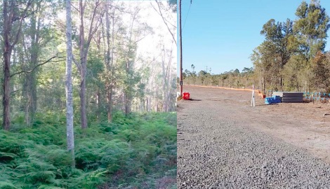

Massive clearing in Ourimbah Rd, Kangy Angy, to make way for the NSW Government’s Intercity Rail Fleet Maintenance Facility, has already turned pristine E2 and E3 bushland into a desolate wasteland, according to residents.
They know they’ve lost the war, but members of the Kangy Angy Residents’ Action Group (KARAG) do battle every day to hold to account Transport for NSW and its contractor, John Holland, as the land clearing commences to make way for the NSW Government facility that will maintain its new intercity fl eet of trains. It could’ve been built on industrial land at Warnervale, but the former Wyong Council, having other plans for Warnervale, encouraged Transport for NSW to acquire E2-E3 wetlands at Kangy Angy. The sale of the Kangy Angy land went through while Central Coast Council was under administration. A plea from the elected Central Coast Council to move the project to Warnervale was ignored by Transport for NSW. Parliamentary Secretary for the Central Coast, Scot MacDonald, recently turned the first sod for work at Kangy Angy to commence and, since then, residents continue to witness the devastation of their semirural neighbourhood.
A resident recently found a dead baby platypus, whilst another family believes endangered pigmy possums have been rendered homeless by the land clearing.
“As you turn right into Orchard Rd, it is horrendous, all the trees are gone,” said KARAG spokesperson, Tracey Stewart. “Then when you come back out and drive along Enterprise Dve, at Chittaway Rd, all the trees are gone, because they are starting to take the trees out for the rail bridge,” she said. “No, we did not anticipate it being this bad, especially along Ourimbah Rd, where we had the expectation that the foliage along the road was going to be retained.” When the clearing along Ourimbah Rd commenced, residents called Jamie Seaton, the John Holland officer responsible for liaising with residents.
“He came down with a map and said, ‘oh no, because we are changing where the power lines are going, we had to take that foliage too.” Stewart said Transport for NSW continues to change its plans and produce new diagrams, but they are not being released to residents.
She said a makeshift crossing of Bangalow Creek has been built, which resembles a “dam wall, will narrow pipes at the bottom, but Holland and Transport for NSW claim the works will not impact on creek flows. “When you drive down Orchard Rd, all the trees are gone, they have ripped all the trees out of the E2-E3 area. “I would describe it as desolation, all the trees have been ripped out, it is a wasteland, it is heart-wrenching.” The residents are hoping that mounds will be built and new trees planted to provide some buffer between their homes and the industrial site when it is built.
“But because John Holland have been having individual meetings with individual property owners and not with us as a whole group, they are saying different things. “I think they do know what they are doing, they are just not prepared to tell us. “If we did this, if we destroyed E2-E3 land, we would be facing criminal charges, but the NSW State Government has carte blanche to do whatever they like, where ever they like. “This defies belief and logic and common sense; you are putting heavy industry buildings and infrastructure into a semirural residential area.
“At Warnervale, you wouldn’t be having any of these issues, you wouldn’t be dealing with the neighbours, you wouldn’t have the issues of Bangalow Creek, the land at Warnervale is zoned correctly.” In addition to having to fight for access to any amended plans for the development, residents have had to respond to an addendum to the Review of Environmental Factors for proposed changes to construction site access, and have been presented with a heavily redacted version of the biodiversity offset strategy that was a condition of the project going ahead.
“We had to have a submission in by Monday last week, because the bridge is going to be built concurrently with the facility now, so they are going to use Hereford St and take all the heavy vehicles through there to bring all of them adjacent to the railway line. “They always knew they couldn’t access Turpentine Rd because of the low rail underpass, which is why they were going to build the bridge over the railway line first and not commence construction of the maintenance facility until the bridge was in place.
“Now they are going to do all the work concurrently and not wait for the bridge to be built first, so they plan to use Hereford St, which is zoned industrial, but still use Turpentine, Ourimbah and Orchard Rds for all their vehicles to come into their site. “If they are using Hereford St for heavy vehicles, then why not use Hereford St for everything, especially when you consider that the residents paid for Turpentine, Ourimbah and Orchard Rds to be tarred.”
Source: Interview, Jul 23 Tracey Stewart, KARAG Jackie Pearson, journalist